


Ross communities' flood fears rise as report prompts calls for action
Register for free to read more of the latest local news. It's easy and will only take a moment.

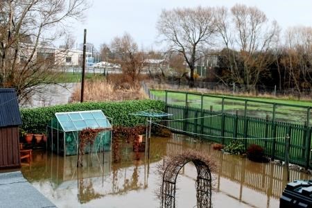
SCORES of homes and business, stretches of roads and a railway line in the Dingwall and Strathpeffer area are all at high risk of flooding within the next decade.
Heritage sites including Castle Leod, Strathpeffer Spa Gardens and Loch Kinellan have also been placed in the high-risk category - reckoned to be a 10 per cent chance each year.
The details are set out in an offical report which for the first time spells out the impact of future floods in the two communities.
Three hundred homes and businesses are facing a medium risk of flood - reckoned to be a five per cent chance of flooding each year.
And 410 properties are in the low-risk category - facing 0.01 per cent chance each year.
Over a 23-mile radius, 40 stretches of road, 20 sections of the Wick to Inverness railway line and half a square mile of farmland are all in the high risk category.
Three schools, a health centre, 10 electricity sub stations, a mineral and fuel extraction plant, about a mile of farmland and 100 stretches of road and 30 sections of the railway are at medium or low risk.
Experts warn existing flood defences on the River Peffery are not capable of giving maximum protection and rainfall is predicted to get heavier.
The statistics have sparked calls for Highland Council and the Scottish Government to build barriers and divert watercourses, but it could be several years before funding is available.
A Dingwall homeowner whose Burns Crescent house was flooded in recent years said she could not afford to wait much longer for protection from the River Peffery.
Olivia Fraser said: “Home insurance is already costing us £3,000 a year and no other company will take us on if we get flooded again. This is no way to live.”
Mrs Fraser explained that flooding was “a constant worry”.
“Trying to explain to people how this feels when they’re not in our situation is just impossible,” she said.
The report by the Scottish Environmental Protection Agency (SEPA) and Highland Council says half of the flooding at Dingwall and Blairninich will be caused by the River Peffery.
Coastal flooding is also a major threat, estimated to represent about 40 per cent of instances, and surface water run-off will play a part in the devastation.
Potential remedial measures include building defences along the River Peffery to the east of Blairninich and through Dingwall.
There are also propsals to use land between the railway and Dingwall Business Park to engineer a flood water storage area. .
The council is responsible for maintaining existing defences and this funding will be allocated form its revenue budget.
The local Flood Risk Management Plan is available to view online at https: /frm-scotland.org.uk/ or at the Highland Council headquarters at Glenurquhart Road, Inverness for the next three months.