


Met Office yellow weather warning for heavy rain will take effect in Ross-shire earlier on Sunday than originally planned
Register for free to read more of the latest local news. It's easy and will only take a moment.

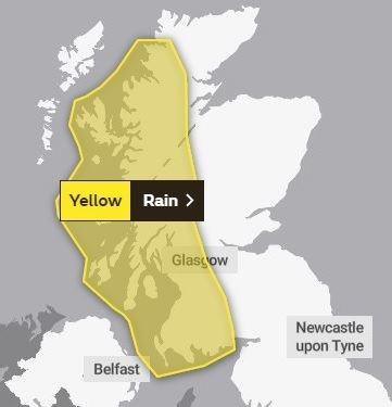
A YELLOW weather warning for heavy rain in parts of Ross-shire will now come into force hours earlier than originally predicted, the Met Office has revealed.
A warning for torrential rain was expected to come into effect at 6pm tomorrow (Sunday) and remain in place until 6am on Tuesday.
However, the rain is now predicted to arrive earlier in the afternoon on Sunday, shifting the warning period forward to 3pm tomorrow. It will remain in place until 11.59pm on Monday night.
Much of Scotland's west coast is affected - including all of Wester Ross and as far east as Mid Ross and the western fringes of the Beauly and Cromarty Firths.
The Met Office believes that around 100mm to 150mm of rain could fall locally on higher ground, with around 25mm to 50mm being forecast more widely around the affected area.
"A spell of heavy rain is expected across parts of western Scotland which may lead to some flooding and travel disruption," said a Met Office spokesman.
"Where flooding occurs, there is a slight chance of delays or cancellations to train and bus services.
"Spray and flooding could lead to difficult driving conditions and some road closures.
"There is a small chance that homes and businesses could be flooded, causing damage to some buildings," they added.
For the latest weather warning updates, visit the Met Office website.
Highland Council has also urged people to keep an eye on the Scottish Environment Protection Agency's Twitter feed (@ScottishEPA) for flood alerts.