


UK on rare red alert for the arrival of Storm Eunice as weather warnings in place across the country
Register for free to read more of the latest local news. It's easy and will only take a moment.

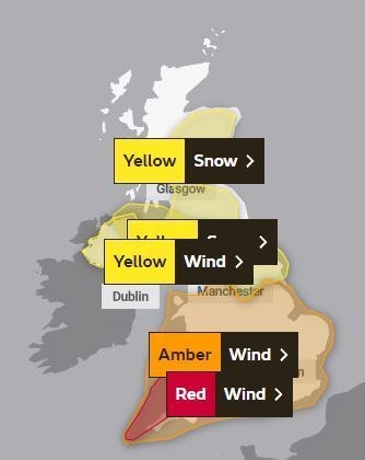
The Met Office has issued a rare red weather warning as Storm Eunice is expected to bring extremely strong winds and continued disruption for much of the UK tomorrow.
The red alert for wind covers southwest coastal areas of the UK, where the most significant gusts in exposed areas could be in excess of 90mph from early morning.
PICTURES: Flooded roads in Ross-shire and region braces for Storm Eunice
Further inland and within the wider amber warning area, gusts will still be significant and damaging for many, with 70mph to 80mph gusts possible.
Red weather warnings are rarely issued by the Met Office, with the last one coinciding with Storm Arwen in November, last year, but the previous one to that was in March 2018.
The warnings reflect the expected track of Storm Eunice eastwards across the central portion of the UK, with the strongest winds expected to the south of Eunice.
On the northern flank of Storm Eunice, there’s a risk of snow for some in Northern Ireland, northern England and southern Scotland.
A yellow warning has been issued for snow, highlighting possible blizzard conditions for these areas including in the Highlands frm 3am to 6pm tomorrow.
The weather alert for the region states: "Storm Eunice may cause disruption due to heavy snow and some strong winds on Friday."
Met Office Chief Meteorologist Frank Saunders said: “After the impacts from Storm Dudley for many on Wednesday, Storm Eunice will bring damaging gusts in what could be one of the most impactful storms to affect southern and central parts of the UK for a few years.”
“The red warning area indicates a significant danger to life as extremely strong winds provide the potential for damage to structures and flying debris.
"Although the most exposed coastal areas in the south and west could see gusts in excess of 90mph, winds will remain notably strong further inland, with gusts of between 70-80mph for most within the amber warning area.”
Katharine Smith, Environment Agency Flood Duty Manager, said: “Strong winds could bring coastal flooding to parts of the west, southwest and south coast of England, as well as the tidal River Severn, in the early hours of Friday morning.
"This is due to Storm Eunice resulting in high waves and potential storm surge coinciding with the start of a period of spring tides.
National Highways Head of Road Safety, Jeremy Phillips, said: “We’re encouraging drivers to check the latest weather and travel conditions before setting off on journeys and consider if their journey is necessary and can be delayed until conditions improve.
"If you do intend to travel, then plan your trip and take extra care, allowing more time for your journey.
“In high winds, there’s a particular risk to lorries, caravans and motorbikes so we’d advise drivers of these vehicles to slow down.
“Drivers of other vehicles should be aware of sudden gusts of wind which can affect handling and braking, and give high-sided vehicles, caravans, and motorbikes plenty of space.
"In the event of persistent high winds we may need to close bridges to traffic for a period, so please be alert for warnings of closures and follow signed diversion routes.”
People should make preparations, secure garden furniture and bins, avoid parking near trees and remain cautious.
Storm Eunice follows on from Storm Dudley that brought high winds for many in the UK late on Wednesday and into Thursday.
In provisional figures, the highest gust speed captured by Met Office weather stations on Wednesday was 81mph at Capel Curig in Wales.
Flooded roads in Ross-shire as region braced for Storm Eunice